Asset Publisher
Using Coodinate Systems in CartoDruid (EPSG or SRID)
Although on the web you can find a lot of information about Cartographic Reference Systems, below we will see a brief description of them and their application in CartoDruid.
Índice
Cartographic Reference Systems
One of the main characteristics of GIS is the possibility of uniquely locating any point within the earth's surface using coordinates. These can be geographic coordinates (longitude, latitude and height) or planar or projected coordinates (X, Y, Z. Cartesian or planar), they are called Coordinate Reference Systems.

Source: https://es.slideshare.net/VictorGonzalezF/coordenadas-geogrficas-y-planas
When we start a project in the professional field, or when we simply want to extract information from a set of layersl, using GIS software, the first question that arise is: what is the extension of the study and in what spatial framework should I work in?
All Coordinate Systems are associated with a code that uniquely identifies them through which we can know the parameters associated with it. It is the SRID (Spatial Reference System Identifier) ¿¿or Spatial Reference Identifier. It is a standard unique identifier of type numeric.
EPSG is the acronym for European Petroleum Survey Group, an organization related to the oil industry in Europe. This organization was made up of specialists in geodesy, topography and cartography applied to the exploitation area and developed a repository of geodetic parameters that contains information on ancient and modern (geocentric) reference systems (frames), cartographic projections and ellipsoids from around the world.
Also, the term EPSG, which is directly related to the term SRID and which is actually equivalent . In fact, if you use any GIS software (such as ArcGIS, QGIS or gvSIG), they refer to Coordinate Systems referring to the term EPSG, however others will refer to the term SRID, including CartoDruid.
Regarding their importance, we can say that they are widely used in the definition of position data in Geographic Information Systems, so it is very useful to know them for all those activities that require managing or manipulating spatial data in digital environments.
We can directly consult the EPSG / SRID codes internationally by accessing the address http://spatialreference.org/ref/
Search:

Description of the EPSG / SRID:

The EPSG / SRID codes that interest us in Spain can be consulted here.
| EPSG codes | EPSG (European Petroleum Survey Group) description |
|
epsg:3034 |
ETRS89/ETRS-LCC: pan-European coordinate reference system for mapping at IDEE (Spanish Spatial Data Infrastructure) scales of 1:500.000 and smaller |
|
epsg:3035 |
ETRS89/ETRS-LAEA For IDEE (Spanish Spatial Data Infrastructure) pan-European statistical representation and analysis |
|
epsg:3395 |
WGS84 Mercator |
|
epsg:3785 |
Google Pseudo-Mercator projection (WGS84) |
|
epsg:3857 |
WGS84 / Pseudo-Mercator projection |
|
epsg:4230 |
ED50 geographic coordinates |
|
epsg:4258 |
ETRS89 IDEE Ellipsoidal coordinates |
|
epsg:4267 |
North American Datum Geographic Coordinates, 1927 (NAD 27) |
|
epsg:4269 |
North American Datum Geographic Coordinates, 1983 (NAD 83) |
|
epsg:4324 |
WGS 72BE Geographic Coordinates, Transit Broadcast Ephemeris |
|
epsg:4326 |
WGS84 datum, Geographic Coordinates |
|
epsg:23028 |
UTM projection, ED50 datum, Grid 28 N |
|
epsg:23029 |
UTM projection, ED50 datum, Grid 29 N |
|
epsg:23030 |
UTM projection, ED50 datum, Grid 30 N |
|
epsg:23031 |
UTM projection, ED50 datum, Grid 31 N |
|
epsg:25828 |
UTM projection, ETRS89 datum, Grid 28 N |
|
epsg:25829 |
UTM projection, ETRS89 datum, Grid 29 N |
|
epsg:25830 |
UTM projection, ETRS89 datum, Grid 30 N |
|
epsg:25831 |
UTM projection, ETRS89 datum, Grid 31 N |
|
epsg:32628 |
UTM projection, WGS84 datum, Grid 28 N |
|
epsg:32629 |
UTM projection, WGS84 datum, Grid 29 N |
|
epsg:32630 |
UTM projection, WGS84 datum, Grid 30 N |
|
epsg:32631 |
UTM projection, WGS84 datum, Grid 31 N |
|
epsg:900913 |
Google Mercator projection |
Using EPSG (SRID) Codes in CartoDruid
Next we will see in which CartoDruid settings EPSG / SRID codes are used.
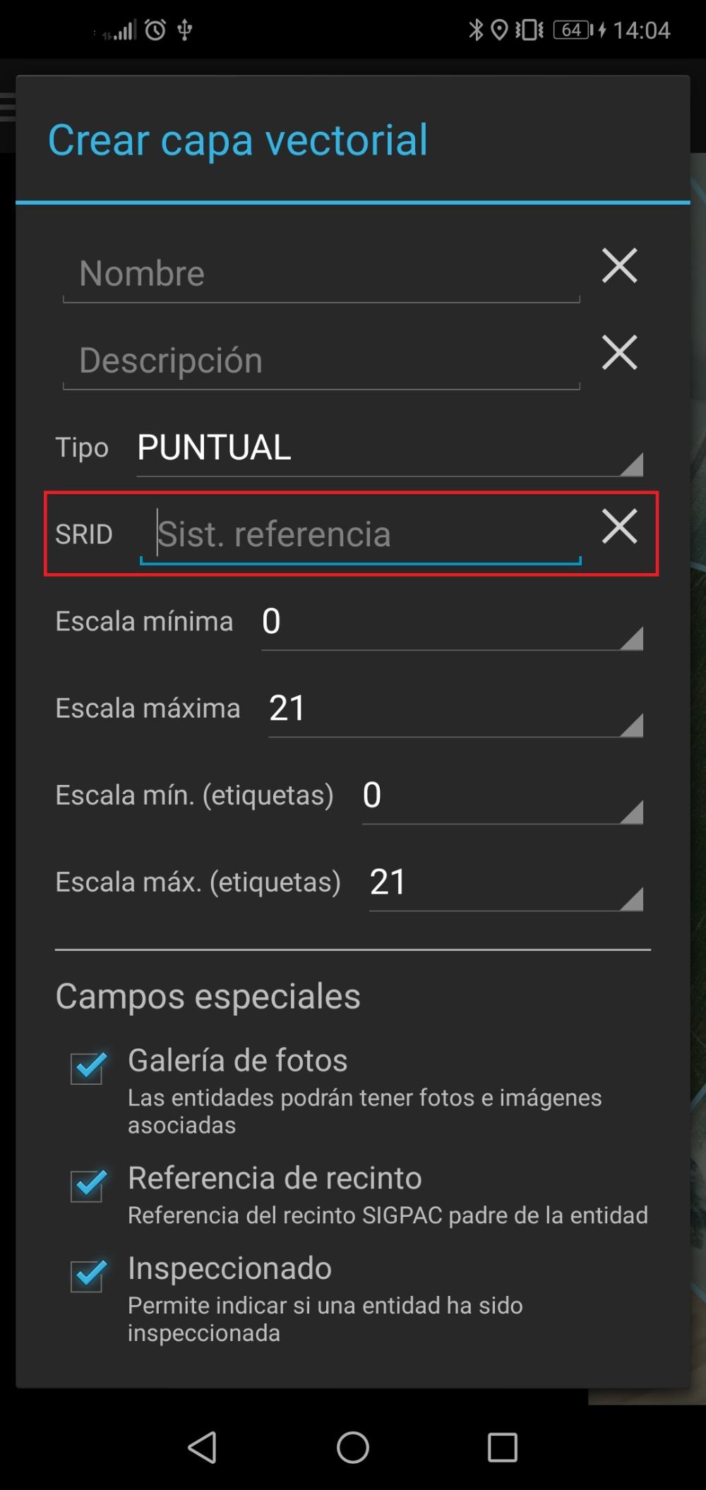
- When we want to create a new vectorial layer. One of the options we have before creating it is to set the SRID or accept it if it comes by default.
- In CartoDruid Settings we have two options related to SRID.

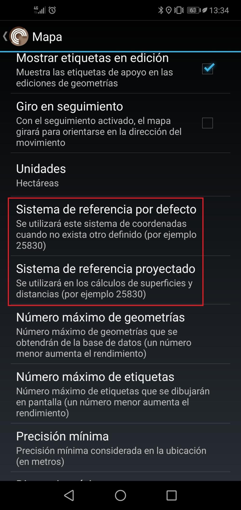
-
Default reference system: It is used to indicate the SRID code of the reference system that will appear by default when, for example, we create a new vectorial layer.
-
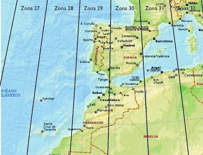
Projected reference system: Although CartoDruid works internally in the world geographic coordinate system WGS84 (World Geodetic System 84), to show us the surface and the distance correctly it must project to a reference system, which must be chosen by the user depending on the area in which is located and the UTM zone (zone) to which it belongs.
-
For example, if we are working in Castilla y León, in the Valladolid area, we will use SRID 25830 which corresponds to the ETRS89 projected coordinate system UTM 30 North zone; if we are in Zamora we will use the SRID 25829 which corresponds to the projected coordinate system ETRS89, UTM 29 North zone. In the Canary Islands we will use SRID 25828 which is an ETRS89 UTM 28 North zone.
Zones UTM (Universal Transverse Mercator)
-


