Asset Publisher
Avanced LPIS (SIGPAC) search
You may have tried to perform SigPac searches from CartoDruid and were unable to, or simply the data provided by the platform for download are not what you need and therefore it is necessary to configure its operation. For CartoDruid to be able to perform this type of search, it is necessary that the SigPac data are loaded and the configuration of where CartoDruid has to locate the search data is well done.
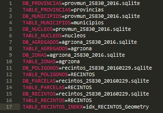
The configuration of the SigPac search is done from the sigpac.properties file which is located in the cartodroid\config folder. In the following image we see a typical configuration of the configuration file for the search:
We will break down each of the tags of the configuration file (one for each line of the file).
DB_PROVINCIAS, DB_MUNICIPIOS, DB_NUCLEOS, DB_AGREGADOS, DB_ZONAS, DB_POLIGONOS, DB_PARCELAS, DB_RECINTOS.
These lines of the file indicate which database (sqlite file) contains the data of the entities corresponding to each of the lines. In this case, the entities of province, municipality, and nuclei are in the file provmun_25830_2016.sqlite, while the data of the entities of polygon, plot, and precinct are contained in the file recintos_25830_2016.sqlite.
The definition of the Database on which the data of the entities are collected has a series of characteristics that need to be highlighted.
- The names of the files do not have to have a defined nomenclature. That is, in principle, the sqlite files can have any name.
- CartoDruid not only loads the file indicated in the DB_xxxx tags but can also collect information from all the files that have as a prefix the indicated name.
For example, if I define the following line DB_RECINTOS=file recintos_25830_2016.sqlite
not only the data of the file recintos_25830_2016.sqlite will be loaded but also, for example, the files recintos_25830_2016_05.sqlite and recintos_25830_2016_09.sqlite will be loaded.
- The files do not have an associated path as CartoDruid searches the entire device for the indicated file. We can have the files in any directory both on the same device and on the external memory that the application recognizes and works with them.
TABLE_PROVINCIAS, TABLE_MUNICIPIOS, TABLE_NUCLEOS, TABLE_AGREGADOS, TABLE_ZONAS, TABLE_POLIGONOS, TABLE_PARCELAS, TABLE_RECINTOS
These tags define the tables that contain the data of the corresponding entities.
In the example we presented, for the entries of TABLE_POLIGONOS, TABLE_PARCELAS, TABLE_RECINTOS the value is the same RECINTOS. This means that it will collect for the search the values contained in the RECINTOS table.
The fields from where the values that CartoDruid shows for each type of entity are collected are predetermined and in the tables, they must be called in the following way
- c_provincia
- c_municipio
- c_agregado
- c_zona
- c_poligono
- c_parcela
- c_recinto
In the previously shown example, the data of the plots that we have to select will be collected from the c_parcela field of the RECINTOS table of the databases that correspond to the name recintos_25830_2016*.sqlite within any folder of the device.
TABLE_RECINTOS_INDEX
Through this tag, the spatial index of the precinct table is indicated. It is not used for the search but for other functionalities of CartoDruid that we will see later.
SIGPAC Information outside of Castilla y León
From ITACyL we are in charge of publishing SIGPAC cartography ready to work with CartoDruid,