Asset Publisher
LPIS (SIGPAC) search and basic configuration
One of the most interesting features of CartoDruid is the SigPac search. Since SigPac is the quintessential Geographic Information System, much of the information or location references we use daily are based on it. CartoDruid provides a tool that allows the search for SigPac references and locating the corresponding plots or precincts. To perform a search correctly, it is necessary to have precinct data and for the search configuration to be correct.
Performing a SigPac Search
The SigPac search button is located in the main menu of the application.
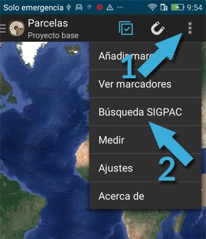
Once the button is pressed, a form is displayed in which the province, municipality, aggregate, zone, polygon, plot, and precinct you want to search for are selected through different combos.
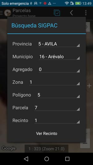
It is not necessary to go as far as the precinct to be able to perform a search since we can search for a municipality if the search table is geographical, for example.
When clicking on "View Precinct," the application zooms in on the selected precinct.
Configuring SigPac Search
For the search to work correctly, it is only necessary to download the following files from the cartography page and save them in any directory of the device:
Data of provinces and municipalities
Aspects to consider when downloading and saving data on the device:
- Since precinct data weighs several GB, we have divided it by province. CartoDruid can handle multiple provinces without problems, so you can download as many provinces as you need, and CartoDruid will transparently use the data it needs.
- CartoDruid is prepared to search for working data in any path of the device, so you can leave the files you have downloaded in any location on the device (both internal storage and memory cards).
If the basic configuration does not work or it is necessary to load other areas that we do not provide by default, you can read the following article explaining how the configuration works in an advanced way.
SIGPAC Information outside of Castilla y León
At ITACyL, we are responsible for publishing SIGPAC cartography ready to work with CartoDruid, but only for the geographical scope of our Community. If you need to use CartoDruid in another area, in this post we show you how to build a SIGPAC precinct layer yourself from Shapefile or WFS sources, this information can be found on the open data portal of your Community.