Asset Publisher
Import files into existing layers
Import data into your existing vector layers
In CartoDruid, we offer the functionality to import data directly into existing vector layers within your project. This option allows you to feed, update, and enrich your geographic information in just a few clicks.
We divide this import process into two modes:
1. Importing from files with inherent geometry
If you already have files containing defined coordinates or geographic features, you can dump them directly onto the vector layer you are using.
CartoDruid is compatible with the most widely used formats in the GIS sector:
- ¿¿¿ Shapefile (.shp): The classic vector format, ideal for interoperability.
- ¿¿ GeoPackage (.gpkg): The modern, lightweight, and versatile standard.
- ¿¿ GeoJSON (.geojson): Perfect for exchanging structured data on the web.
- ¿¿ GeoCSV (.csv ): Ideal for tabular data tables incorporating spatial attributes or coordinates.
- ¿¿¿ SpatiaLite (.sqlite): Excellent for managing spatial data volumes directly within a database.
- ¿¿ KML (.kml): Very practical for sharing information exported from Google Earth or other visual tools.
2. Importing via LPIS (SIGPAC) parcel references (CSV files)
Sometimes, the geometry you want to load is not directly available, but you do have its LPIS (SIGPAC) reference. In these cases, in order to load the geometries into CartoDruid, it is an essential requirement to have a valid LPIS vector layer loaded in your project. The import process will be carried out using a CSV file.
CSV file options and formatting
CartoDruid offers great flexibility when processing your CSV files depending on the structure of the file:
- Ficheros solo con la referencia SIGPAC:
- No header required: If the CSV contains only the reference data, including a first row with column names is not mandatory.
- Supported formats and valid reference examples:
- o Semicolon-separated (
;):
- o Semicolon-separated (
24;1;0;0;1;1;1 (Provincia; Municipio; Agregado; Zona; Polígono; Parcela; Recinto)
-
-
- o Comma-separated (
,):
- o Comma-separated (
-
24,1,0,0,1,2,1 (Provincia, Municipio, Agregado, Zona, Polígono, Parcela, Recinto)
-
-
- Continuous 23-digit format:
-
24001000000010000100002
- Files with LPIS reference + additional attributes:
- LPIS reference in 23-digit format with the field name C_REFREC
- If, in addition to the LPIS reference, you wish to import other information into the layer (for example, crop type, observations, date, etc.), the CSV file can include any additional required columns.
¿¿ Key Aspect: Field Mapping
In order for alphanumeric information (column data or attributes) to be correctly transferred from the source file to the target vector layer, field names must match exactly.
¿¿ Important Note: If a field in your source file has a different name than the corresponding field in the target layer's attribute table, that data will not be imported. Make sure to review and align your column headers before running the import process.
¿¿ Step by Step: How to Run the Import in CartoDruid
Follow these simple steps within the application to import your files:
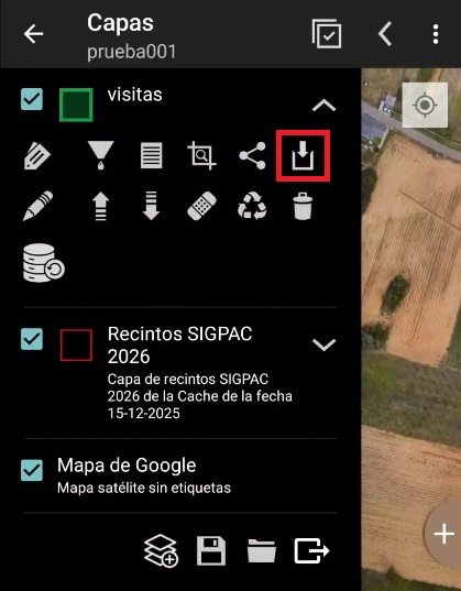
- Select the data import button on the target layer in the la TOC (Table of Contents):
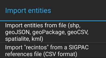
- Select the import type: File with inherent geometry or via LPIS (SIGPAC) reference
- Once you have selected the import type, the device's file browser will open so you can select your file. In the case of Shapefiles (.shp), all necessary files (.shp, .dbf, .prj, etc.) must be located in the same folder, or all compressed together into a single .zip file from which you select the archive to import.
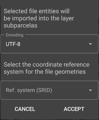
- Select the reference system (CRS) and encoding of the file. If the file format does not specify the encoding and/or reference system, a dialog box with dropdown menus will appear so you can select them.
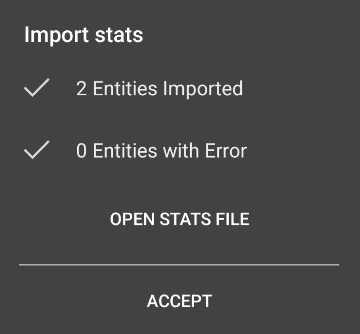
- Once the file is loaded, a summary of the import process will be displayed, along with a link to the log file showing load statistics and any errors encountered.